Digital Signage: Advances in interactive wayfinding content
by all | 28 July 2013 8:30 am
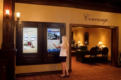 [1]
[1]Photos courtesy X2O Media
By Maria Porco
Wayfinding in large, multi-building facilities has undergone tremendous changes over the years. In the beginning, there were paper-based sign systems. When navigating a convention centre, for example, conference attendees would rely on printed maps and large posters to direct them to their meeting room, while agendas taped up outside rooms would confirm they had arrived at the correct place.
One of the obvious drawbacks of these signs was whenever the information changed, they had to be reprinted and posted, which added to event costs. A less obvious drawback, however, was the essentially one-way ‘conversation’ provided by static signs, which missed out on the opportunity to engage visitors in a more meaningful way.
The introduction of digital wayfinding has addressed these and other drawbacks, providing easier navigation within a facility, savings in time and money related to updates, more capacity for directions and schedules and an improved overall experience for users.
You are here … and beyond
In its most basic form, digital wayfinding starts out with a simple electronic map of an area—similar to those found through Google Maps—and presents it as a static image on a large screen. Labelled with the familiar ‘you are here’ indicator, it allows visitors to situate themselves relative to their desired destination and then find their way.
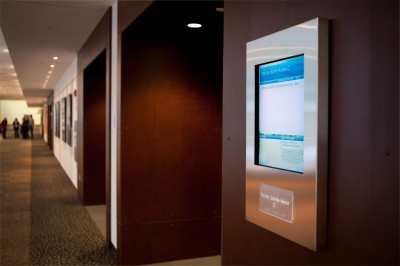 [2]
[2]In Fredericton, N.B., digital signs have been installed for every meeting room within the Fredericton Convention Centre.
The next level of digital wayfinding is an interactive map, which allows users to select their end destination and receive turn-by-turn directions, showing how to get there in a graphical fashion. Interactive maps vary in their level of complexity. The more sophisticated systems provide three-dimensional (3-D) views of the facility, for a better perspective of paths and destinations, making it easier for many users to orient themselves.
Another advance for viewing such maps has been 360-degree panoramic wayfinding. Generally, this involves a touch screen that users swipe to manipulate high-resolution images of locations and amenities, viewing them from any desired angle.
Interactive maps can also provide additional information about those locations and amenities. In some cases, maps are augmented with video and graphical ads from businesses operating in and around the facility, creating an additional source of revenue.
Even an interactive experience does not ensure visitors will remember the directions after they leave the screen, however, so another new trend is to incorporate their own smart phones and tablet computers with the wayfinding system. This way, they can take the map and/or directions with them.
There are several ways this can be accomplished. One is to allow users at a screen to e-mail directions to their own addresses. Another is to display a Quick Response (QR) code on the screen they can scan with their mobile device.
Choosing the right path
Digital wayfinding capabilities can vary widely, so it is important to take a few basic factors into account before selecting a specific platform or system.
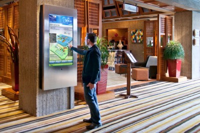 [3]
[3]In the lobby of the Hilton Montreal Bonaventure, visitors can access interactive wayfinding functions through a touch screen.
For facility managers, one of the most important factors will be how easy it is to create and update on-screen content. The digital signage platform should allow staff to update various types of content—such as videos, images and maps—quickly and easily, with minimal training. This is significant in terms of saving time and expense over the life of the network.
In a hotel with a conference centre, for example, it is very important for visitors to see the most up-to-date information about meetings and event schedules, while also preventing errors in data entry whenever possible. This can be accomplished through the tight integration of the digital signage’s wayfinding content management software with the conference centre’s own event management software.
This way, as soon as there is a change in a conference’s schedule, the wayfinding software will automatically update the content on the screens, quickly disseminating the new information to visitors without requiring anyone to make a manual change. For this streamlined update process, an open digital signage platform—i.e. one that can integrate directly with other systems, including third-party software—should be considered.
In many places around the world, including some Canadian cities, public signage must provide information in multiple languages. If a facility falls within such a jurisdiction, it will be important for the wayfinding content management software to support and simplify multilingual content creation. In-software tools like style sheets and templates can allow layouts to be reused while only changing the text portions of the on-screen content, reducing the duplication of effort.
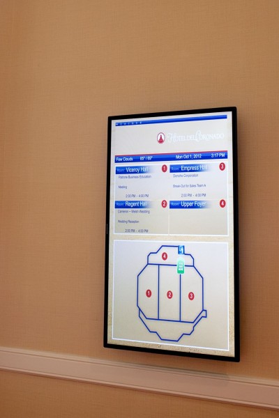 [4]
[4]Interactive maps displayed in a graphical fashion will vary in their level of complexity, depending on the facility.
The next question is what the digital signage network should provide beyond wayfinding. There are many other types of content that can be relevant and helpful to visitors. Hotels near airports, for example, will often use digital signage to display real-time flight arrival and departure information. Some of these systems even allow guests to print their boarding passes.
In hospitals, on the other hand, screens might include a health-themed news ticker and the local weather forecast. In any case, a system that automatically updates information will ensure on-screen content is always fresh and current. And that information can be integrated from live Rich Site Summary (RSS) feeds, social media or any other sources.
Also, if a facility is already equipped with a digital signage network, it is important to check if that system will support an upgrade to interactivity. It is not uncommon for facility managers to install digital signs and then later decide to add interactive features later. If the system does not allow such an upgrade, however, then the facility could well end up with two independent platforms.
Planning the journey
Wayfinding has come a long way, from paper signs to basic digital maps to interactive panoramic views, all with the goal of providing a more intuitive and informative experience for users of the system, whether they are conference attendees, hotel guests or university students.
Even as advanced technology becomes easier to use, however, choosing a wayfinding system still involves careful planning. For any given facility, it is important to focus on the needs of both staff and guests and to consider basic factors related to content, so as to determine what a digital wayfinding system will need to achieve.
Maria Porco is vice-president (VP) of business development for X2O Media, a Montreal-based visual communications software developer that serves the digital signage industry. For more information, contact her via e-mail at maria@x2omedia.com[5].
- [Image]: http://www.signmedia.ca/wp-content/uploads/2014/01/X2O-Media-Hotel-del-Coronado-IMG_7482b.jpg
- [Image]: http://www.signmedia.ca/wp-content/uploads/2014/01/ROB_6259_FCCMeetingRooms.jpg
- [Image]: http://www.signmedia.ca/wp-content/uploads/2014/01/Bonaventure_3.jpg
- [Image]: http://www.signmedia.ca/wp-content/uploads/2014/01/X2O-Media-Hotel-del-Coronado-IMG_7400b.jpg
- maria@x2omedia.com: mailto:%20maria@x2omedia.com
Source URL: https://www.signmedia.ca/advances-in-interactive-wayfinding-content-2/