
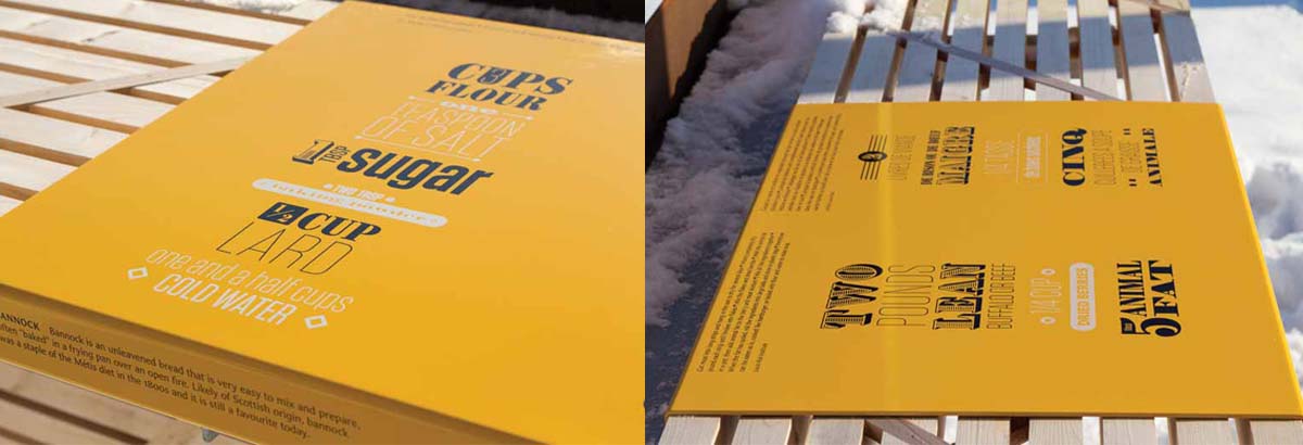
In the picnic area, raised countertops’ panel graphics explain modern cooking techniques for traditional dishes.
The visitor’s journey
The first structure a visitor encounters when travelling to the village site is the ‘viewing lens,’ where cedar planks represent a series of river lots running parallel to each other. This interpretive node sits atop a hill, providing a vantage point to introduce the landscape. A two-panel informational sign on one of the walls provides context.
A 730-m (2,395-ft) walk west down the linear path—or ride on the shuttle bus—toward the river leads the visitor to the next structure, the ‘platform,’ which comprises two bodies of weathering steel connected by a wooden stage. Stairs take the visitor up into the first chamber, an open-air enclosure where a pair of interpretive panels set to the left side—combining clear acrylic with screenprinted aluminum—describe how Batoche was chosen as a place to put down roots and what early life was like there. Illustrations show how the river lots were used.
After reading those panels, the visitor turns and walks along the stage as a bridge to the second steel chamber. A 6-m (20-ft) long and 300-mm (12-in.) wide handrail uses screenprinted and clearcoated aluminum to illustrate Batoche’s central position among the trade routes over land and water. It allows the visitor to visualize what the village would have looked like, by superimposing photos of buildings on the landscape.
In the second chamber, which opens to the sky above, a 5.3-m (17-ft) tall timeline provides an overview of the settlement’s history, with bent metal strips screenprinted with dates and information in English and French marking 50-year spans. By projecting up through the opening, it is meant to suggest an infinite future for the Métis. In addition, the Métis flag—which features the infinity symbol—flies above the tower.
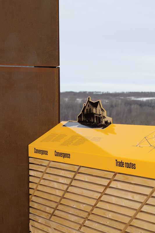
A handrail superimposes photos of historic buildings on the landscape to help visualize what the village of Batoche looked like.
After exiting the platform, the visitor returns to the land and ends the journey in the family garden. At the centre of this area is the trade route playground, a three-dimensional (3-D) scaled map that demonstrates how people and goods would have moved across Northwestern Canada. Major trading posts and Métis communities are indicated with large, upright log markers, which also serve as beacons above newly introduced saskatoon berry hedgerows. Horizontal half-sawn logs symbolize the main trails.
In the family garden’s picnic area, raised countertops feature ‘placemat’ graphics of the foods that were eaten in Batoche. These panels are evocative of 18th– and 19th-century posters, but provide modern cooking techniques and ingredients for traditional fare, including boulettes, bannock, chokecherry syrup and Saskatoon berry crumble. A nearby sandbox demonstrates food preservation techniques, including root cellaring and the use of a pemmican stone to pulverize dried meat.
Fulfilling the vision
Parks Canada’s multi-faceted goal for this project was to allow the landscape to tell the story of a thriving culture, strengthen ties and serve as a destination. Through a combination of interpretive planning, graphic design and architecture, Form: Media found a way to fulfil that goal.
The site opened in August 2016. The following June, it was honoured both with a People’s Choice Award in the inaugural experiential graphic design category of the seventh annual AZ Awards and as a finalist for the annual Society for Experiential Graphic Design (SEGD) Awards in the U.S.
John deWolf is vice-president (VP) of Form:Media in Dartmouth, N.S. For more information, visit www.form-media.ca.


