Urban wayfinding planning and implementation
by all | 21 January 2014 8:30 am
Photos courtesy ISA
By John Bosio, Craig Berger and Sapna Budev
Over the last 20 years, many urban areas—from small-town main streets to the downtown districts of the world’s largest cities—have seen new wayfinding and identity systems installed to ease navigation, enhance their brand and/or reinforce key destinations. One of the reasons for a heightened interest in effective wayfinding is the desire to enhance jurisdictions’ economic sustainability. In this context, sign systems have taken on a revitalized importance.
Some of these wayfinding projects have developed to the point where they are integrated into local traffic control standards and accepted as part of ongoing financing programs. Yet, there is often little information available to signmakers, urban planners and city officials who want to develop new sign programs and learn from those cities that have already been successful. This information is crucial, given such projects may take two years from conception to installation.
The case for wayfinding signs
Visitors often navigate cities these days using smartphone apps that find destinations—and information about them—within seconds. With such tools at their disposal, they may well wonder if physical wayfinding elements are even necessary anymore.
Municipal wayfinding systems, however, serve important roles well beyond the basic needs for navigation, identification and information. Monuments, directional signs, interpretive panels, directories and even regulatory signs can all enrich the urban environment experience.
For one thing, signs define a sense of place. Urban geographer Ken Lynch suggests all cities have their own language, which residents and visitors can ‘read’ in their streets, landmarks, districts and gateways. Lynch’s research method of testing city legibility through personal cognitive maps has shown the effectiveness of successful wayfinding systems.
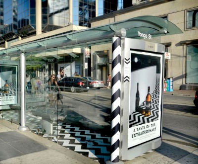
In Toronto, Kramer Design Associates (KDA) and Astral Out-of-Home have integrated a program under city oversight, where commercial advertising is used to fund street furniture and wayfinding signage. Photo courtesy Astral Out-of-Home
They can also highlight complementary destinations, bringing greater awareness to lesser-known landmarks that may not be included in apps. In Lancaster, Penn., for example, the installation of a citywide wayfinding system in 1999 led to increased name recognition for secondary destinations, including the city’s Art Museum and Central Market.
Even when drivers use Global Positioning System (GPS) devices, vehicular wayfinding signage is beneficial, as locating the destination is not the only key issue. Signs are also used to control traffic circulation patterns and consistently identify parking lots and garages. By providing clear directions to drivers at strategic locations, signs can reduce confusion and distraction and help create safer conditions.
Finally, in cases where individual organizations within the same district implement unique sign systems, particularly in terms of specialized banners, redundant neighbourhood identification and private interpretive efforts, the urban environment can appear disjointed and disorganized. A well-defined, comprehensive municipal wayfinding system will help create a consistent urban brand, a sense of organization and a perception of quality for the city and its amenities.
System elements
A wayfinding system has many parts that fit together, including colours, typography, shapes, logos, materials and nomenclature.
Gateway signs define entry to a distinct place, with its own identity. Regional gateways may apply to a province, county, heritage area or economic zone (e.g. industrial or commercial corridor). City gateways, which identify a city or town, may lead to district and neighbourhood gateways (e.g. Chinatown) and area identification gateways for less defined areas with distinct culture or commerce (e.g. fashion district) or political importance.
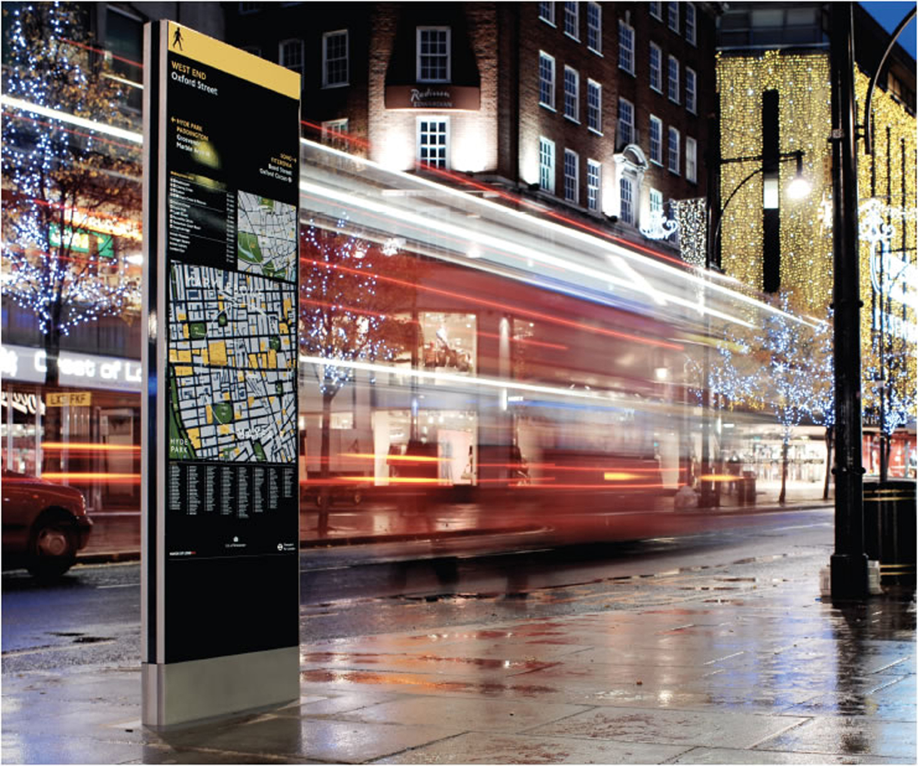
The aforementioned vehicular wayfinding signs are accompanied by pedestrian wayfinding signs, maps and directories. Of course, street name signs, regulatory signs, street furniture, public art, civic banners and informational kiosks also support the notion of an overall wayfinding system.
Getting started
A great deal of preparation is required before establishing a wayfinding plan and unveiling a design concept.
A new sign system, like a bridge or a highway, will affect a number of stakeholder constituencies. Signmakers will benefit if these constituencies are consulted from the outset of a project. They may include a steering committee, management committees, task forces and general stakeholders, such as political and community leaders, funding agencies and the media.
The project team will refine the project’s scope and strategic approach, which may lead to preliminary design descriptions and recommendations. The planning process will include research of best practices, pedestrian and vehicular circulation routes, field conditions and existing sign messaging protocols, as well as surveys of residents, visitors and other stakeholders, before outlining a strategy and early design concept report.
Wayfinding systems include not only signs, but also informational kiosks, maps, directories and other supportive elements.
There is often a great deal of pressure to complete a wayfinding program with one project, but there are many advantages to a multi-stage approach. Developing the program in one location, for example, allows a ‘trial run’ for approval, fabrication and implementation and testing.
System financing
It is also important for signmakers that the process secures financing. Politicians and community leaders can help secure support and defend decisions. Leading sources of funds include grants, donations, business improvement areas (BIAs) and government funds at the municipal, provincial and/or federal level.
In Calgary, for example, a new downtown wayfinding system (see Sign Media Canada, July 2013, page 38) is primarily being funded through downtown improvement and beltline community investments. These funds are generated through downtown licensing fees and developer contributions that are earmarked for public-space improvement projects.
In Toronto, meanwhile, Kramer Design Associates (KDA) and Astral Out-of-Home have integrated a program under city oversight where commercial advertising is used to fund street furniture and wayfinding signage.
Meeting regulations
Another challenge is managing the regulatory framework. One of the reasons for the recent success of large-scale urban wayfinding systems is many governments have updated their codes over the past 20 years, but roadblocks can still exist.
The unfortunate tendency of sign codes is to specify blanket rules whether signs are in urban, suburban or rural locations. In some cases, for example, codes require wayfinding signs to be too large or too far separated from their points of reference. These regulations may focus on the needs of drivers on roads with high speed limits, but are mismatched for low-speed, pedestrian-oriented areas.
In other cases, codes require gateway signs to be too small and dim. These zoning codes may be designed to limit advertising, but they can lead to legibility issues for people trying to find destinations.
While signmakers might seek a variance or legal exception for one or a few signs, a citywide wayfinding program may require developing a whole new sign code, based on analysis of specific conditions, sound research, case studies and observations of other jurisdictions’ successful regulatory framework. Further, variances often undermine the validity of a code and can make it harder to expand a program over time.
Design
Before the design phase, there should be a ‘design brief,’ outlining the goals and scope of the project. Then, the design phase will usually comprise two parts: (a) schematic/concept design and (b) design development. While these can be combined in some small communities where budgets are restrictive and the wayfinding system simple, the two-part approach is advisable for large urban areas and complex projects with multiple stakeholder groups.
The schematic/concept design phase references feedback from surveys and analyses when developing concepts for sign placements, sizes, materials, standards and costs. This allows an opportunity to revisit the project’s original goals.
The design development phase uses typography, colours, attachments and other specific details to turn the early elements into fully realized concept. It is important to ensure these details receive full regulatory approval before the project moves forward.
To test the designs for proper scale, photographic montages and temporary mock-ups should be developed early in this stage.
Material selection
Wayfinding signs must withstand a great deal of wear and tear, including the effects of air pollution, vandalism and the sun’s ultraviolet (UV) rays, so durable materials are required. Measuring longevity should be an important part of the material specification process.
Paints and coatings, generally, show wear and tear most visibly over time. They should therefore be chosen based on the sign system’s intended lifespan, which may range from one to 20 years.
Digitally printed graphics have improved greatly in durability, but can also fade under intense environmental conditions. Some wayfinding signs are now printed on high-pressure laminates, while others protect vinyl with a weather-resistant coating.
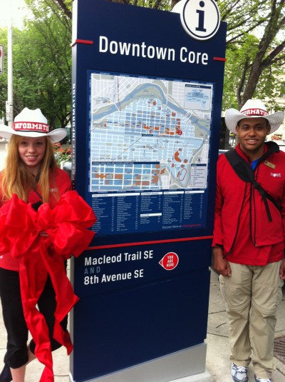
In Calgary, a new downtown wayfinding system is primarily being funded through downtown licensing fees and developer contributions earmarked for public-space improvement projects. Photo courtesy Calgary Downtown Association
Aluminum, steel, wood, stone and concrete can all be used as long-lasting substrates, but durability falls not just on these materials, but on their connectors, which often fail first. Mechanical fasteners and hinges tend to outlast adhesives.
A modular system might include prefabricated boxes, removable messages and standard connectors to allow frequent updates, but multiple parts can also mean they are easier to vandalize.
Fabrication
The construction of wayfinding elements can be the most challenging and stressful phase of the project, not only because the planning and design work must be translated into actual built, installed and maintained signs, but also because civic projects often face fabricator selection rules that can complicate documentation and administration.
The level of documentation should be developed to match the bidding process. Publicly bid projects require exact specifications, while negotiated projects can include more general information and allow the signmaker to propose a customized approach.
A prototype phase is necessary as part of the overall bidding process, especially for public bids, to ensure all entities understand the project. In Banff, Alta., for example, a prototype exploration and rollout plan was key in moving toward an implementation of complex signs, landmarks and banners within a Canadian national park.
Once the chosen sign fabricators have begun work, the wayfinding project team, designers, managing committee and key officials can move on to the administration, monitoring and approval of construction. Communications will remain vital regarding electrical components, deep foundations and/or structural work.
Installation
Any final installation issues should also be resolved before closing the fabrication contract, reviewing the completeness and quality of the installed signs, as well as any safety issues that may not have been foreseen at the planning and design phases.
Additional testing can inform further project development. It is important to check there are enough wayfinding elements for the entire city and the maintenance program will be adequate. The final review should be incorporated into guidelines for ongoing expansion, management and maintenance, ensuring any future design decisions are aligned with the actual fabricated, installed and tested signs.
System management
From regular cleaning to repairs and replacements, maintenance is an ongoing issue, with costs often ranging from seven to 15 per cent of total capital expenditures on a yearly basis.
With this in mind, sign shops should strive to make maintenance as easy as possible for their clients. Elements that will require ongoing management should be easy to open and take apart, while those receiving minimal maintenance should have few removable connections. Lighting will require more extensive maintenance than reflective, non-illuminated signs.
System management should also respond to area-specific hazards. A sign downtown might be vandalized, while one in an industrial area is more likely to suffer vehicular damage.
John Bosio is a partner at Merje, an environmental graphic design (EGD) firm; Craig Berger is associate chair of the visual presentation and exhibition design program for the Fashion Institute of Technology (FIT); and Sapna Budev is director of strategic initiatives for the International Sign Association (ISA). This article is based on a seminar they recently presented at the Signage Foundation’s 2013 National Signage Research and Education Conference (NSREC), as well as on the Urban Wayfinding Planning and Implementation Manual, edited by Berger and developed by the Signage Foundation and ISA. For more information, visit www.thesignagefoundation.org[1] and www.signs.org/wayfinding[2].
- www.thesignagefoundation.org: http://www.thesignagefoundation.org
- www.signs.org/wayfinding: http://www.signs.org/wayfinding
Source URL: https://www.signmedia.ca/urban-wayfinding-planning-and-implementation/